Lake Tahoe’s Best Places to Stargaze
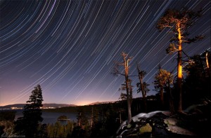
Lake Tahoe boasts up to 300 clear nights per year. The dry air and western on-shore marine airflow pattern are ideal for good “seeing,” as is the low atmospheric turbulence.
I have been leading star parties at Lake Tahoe for ten years and have accumulated a list of my favorite sites (complete with exact latitude/longitude coordinates and basic directions) for taking folks out to observe our magnificent starry nights. These spots include beach, park and mountaintop viewing sites, and are chosen based on my favorable experiences, ease of access for viewing, especially when toting telescopes and bulky equipment, and limited light pollution.
BEACH AND PARK STARGAZING SITES
Baldwin Beach
39.922778n 120.068058w
Highway 89, four miles north of the South Lake Tahoe “Y”
Pros: Minimal light pollution, great north, west and east views across Lake Tahoe, easy access, historic buildings, gardens, restrooms, picnic area, barbecue grills, beautiful beach and pier
Cons: Open only mid-May to October, closing hours vary, admission fee
Nevada Beach
38.981944n 119.955000w
U.S. Highway 50, Round Hill
Pros: Huge open beach and sky view, little light pollution, best sunset view on The Lake, easy access, good parking, restrooms, picnic area, barbecue grills, camping
Cons: Can be very windy in the afternoons, sand is very fine (hard on equipment—be sure to take a blanket for covering sand under telescopes), parking and camping fees
Cave Rock Boat Launch
39.044167n 119.945889w
U.S. Highway 50, immediately south of the Cave Rock tunnels
Pros: Great open sky view to the west, north and south, great sunset view across The Lake, easy access, good parking, rest- rooms
Cons: Can be very windy in summer afternoons, no beach access, moderate light pollution from parking lot and traffic on U.S. Highway 50, parking fee
Sand Harbor – Nevada State Park
39.195833n 119.933333w
Three miles south of Incline Village on Highway 28
Pros: Terrific south-facing beach, boat launch, restrooms, picnic area, barbecue grills
Cons: Some light pollution from Highway 28, parking fee, access limited during Shakespeare events July and August
Burnt Cedar Beach
39.245278n 119.968889w
Lakeshore Drive, Incline Village
Pros: Dark sky with stunning east and south lake views, easy access, restrooms, picnic area, barbecue grills
Cons: Private beach requires Incline Village recreation pass and paid guest pass to enter, limited parking during busy July and August
Secline Beach
39.236944n 120.029444w
Secline Street, Kings Beach
Pros: Superb view of the entire lake looking to the east and south, easy access, no fees, picnic area and barbecue grills
Cons: Some light pollution, which is partially obstructed by trees, fine sand tough on telescopes, limited parking, no restrooms
Sandy Beach
39.236954n 120.048889w
Highway 28 in Tahoe Vista
Pros: Breakwater Park has excellent east and south views across The Lake, easy access, restrooms, picnic area, barbecue grills, boat launch, fee campsites across highway
Cons: Some light pollution from Highway 28 businesses
Lake Forest Beach Park
39.180556n 120.115278w
Bristlecone Avenue in Lake Forest, one mile east of Tahoe City
Pros: Dark site, excellent east, south and west views, easy access, restrooms, picnic area, barbecue grills and playgrounds
Cons: Marsh area can be very buggy in the summer months, limited parking
Commons Beach Park
39.169167n 120.142776w
Highway 28 in downtown Tahoe City
Pros: Great east and south lake views, easy access, free parking, two playgrounds, large lakefront lawn area, rest- rooms, barbecue grills
Cons: Buggy at dusk, moderate light pollution (some hidden by bluffs) from Tahoe City business.
D.L. Bliss State Park
39.997222n 120.098611w
Highway 89, south of Meeks Bay
Pros: Excellent east and south sky views, easy access to beach parking area, rest- rooms, picnic area, barbecue grills, trails and camping
Cons: Fine sand is tough on equipment, busy in the summer, parking fee
MOUNTAIN STARGAZING SITES
Spooner Lake – Nevada Park
39.107778n 119.913889w
Junction of Highway 28 and U.S. Highway 50
Pros: Dark sky with good east and south views, restrooms, picnic area, barbecue grills, fishing, hiking trails
Cons: A quarter-mile trek from parking lot to the earthen dam at north end of lake for best viewing, very buggy during the summer at dusk, parking fee
Sheep’s Flat Recreation Area
39.308944n 119.908333w
Mt. Rose Highway 431, two miles from summit
Pros: Full open sky in meadow, great place for moonlight hikes, easy year- round access, many hiking trails, restrooms at summit trailhead and meadow parking lot, camping at Mt. Rose campground
Cons: Some light pollution from passing cars and Reno sky glow, heavy winter snows can mean late spring thaw, buggy in the summer at dusk
Slide Mountain, Mt.Rose-Ski Tahoe Winters Creek Lodge Parking Lot
39.31667n 119.875w
Mt. Rose Highway 431 to Highway 878, 3.5 miles to the parking lot
Pros: Easy place to set up telescope for dark sky viewing, spectacular views east and south overlooking Washoe Lake, easy year-round access
Cons: Can be very windy and cold even in summer; if lodge is closed, then no restrooms available
Virginia City Highlands
39.341687n 119.541687w
Highway 341 (Geiger Grade) to Lousetown Road, 12 miles from Highway 395
Pros: Open dark sky, many dirt roads with turn-outs, easy year-round access, facilities in nearby Virginia City
Cons: Reno sky glow to the north, can be windy
Barker Pass Recreation Area
39.097222n 120.213889w
Highway 89, 7 miles down Blackwood Canyon Road
Pros: Exquisite dark sky site with large, flat packed dirt parking area at 8,500 feet with stunning whole-sky views, one of the most stunning sites in the region, easy access, many hiking trails
Cons: No facilities or campground amenities at summit, only accessible May through October, though may not open until June if winter snows are especially heavy
Emerald Bay State Park, Upper Parking Lot
39.954167n 120.111111w
Highway 89, south of Meeks Bay
Pros: South end of parking lot has excellent sky views overlooking Emerald Bay, good place to gather a crowd to view through telescopes (“sidewalk astronomy”), easy summer evening access
Cons: Moderate light pollution from cars in parking lot, Highway 89 closed in winter
Pope Valley Along the Carson River
38.776389n 119.920833w
Highway 88, at junction with Highway 89 (Luther Pass Road)
Pros: Very dark skies, excellent observing conditions, easy summer access with many turnouts along the Carson River, close to Sorensen’s Resort
Cons: May be buggy
Red Lake Reservoir
39.698611n 119.970833w
Highway 88, 7.4 miles west of the junction of Highway 89 (Luther Pass Road) in Pope Valley; take Red Vista Road one-quarter mile to the earthen dam at Red Lake
Pros: Very dark skies, excellent observing conditions, easy summer access
Cons: Limited parking, may be buggy
Indian Creek Reservoir
38.744722n 119.783333w
Highway 88 to Woodfords junction, then south on Highway 89 toward Markleeville to Airport Road and Indian Creek Reservoir
Pros: Superb viewing site from earthen dam on west side of reservoir, easy summer access, BLM campground, close proximity to Markleeville services, second excellent site at the Alpine County airport
Cons: May be buggy
Monitor Pass
38.672222n 119.626389w
Highway 395, 2.5 miles south of the Nevada state line, then take Highway 89 west toward Markleeville
Pros: Incredibly dark viewing site with clear views east and south, spectacular scenery, moderately easy summer access
Cons: No facilities or potable water, dusty roads, can be windy early evenings
Category: Best of Tahoe 2011, Natural World


